"We published the Traffic Catalogue before everything was perfect. That decision turned a stalled initiative into something people actually use."
Adam Tafvelin, Tech lead at Devies
How Gothenburg turned fragmented traffic data into a living city planning tool
Gothenburg is a city that never stops moving. Hundreds of thousands of trips happen every day on its streets, and the people responsible for planning those streets need to understand exactly what is happening on them. Stadsbyggnadsförvaltningen, the city’s spatial planning authority, had been collecting traffic data for years. They had sensors. They had suppliers. They had a Traffic Catalogue that had technically existed for a long time. What they did not have was a version of that catalogue that anyone could actually rely on.
The data arrived from several of different sources, each with its own format, its own quality level, and its own logic. Before a planner could use a number, someone had to go find it, clean it, and hope it matched what another department was looking at. One-off requests piled up. Decisions were made based on assumptions instead of facts. The catalogue itself was more of a static snapshot than a living resource. The city had the raw material for data-driven planning. It just had no foundation to build on.
What Devies was brought in to do was not glamorous on paper: build the plumbing. But the plumbing was everything.
Impact highlights
● City planners now design streets and infrastructure based on unified, verified data rather than one-off reports or gut feel
● Citizens can explore real traffic patterns for specific streets through an interactive, public-facing Traffic Catalogue
● Internal teams no longer submit manual data requests; data status and quality are visible directly in the platform
● Other city departments share a single source of truth, eliminating the conflicts that come from siloed views of the same data
● The catalogue launched before it was “finished” and has improved continuously since, based on real use
One data model to replace the chaos
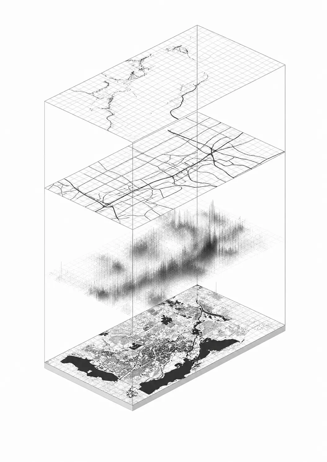
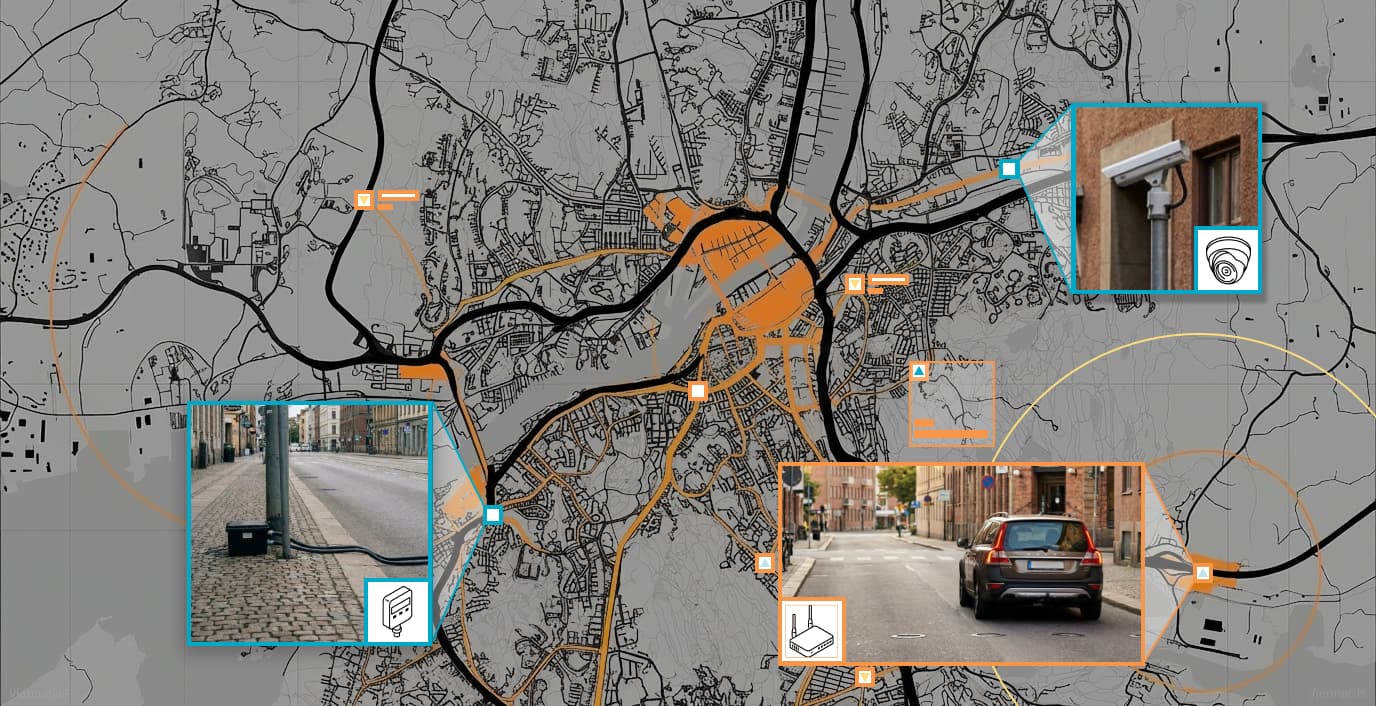
The hardest part of this project had nothing to do with technology. It had to do with translation. Traffic data in a city like Gothenburg does not come from one place. It comes from a wide range of sensors, measurement points, and third-party suppliers, each delivering information in its own format with its own assumptions baked in. Pedestrian counts look different from vehicle counts. Cycling data arrives on a different cadence. Some sources are rich; others are sparse. None of them spoke the same language.
The work was to turn that fragmented input into something coherent: a unified data model that captured all of it, normalised the inconsistencies, and made the result trustworthy enough to build on. That meant going deep into the domain, not just the data. Understanding what a traffic measurement actually represents, where its limits are, and what it should and should not be used to conclude.
Once the data model was in place, everything downstream became possible: stable pipelines, automated quality checks, and reports that departments could actually trust the first time they opened them.
"The biggest challenge was bridging two worlds: deep domain expertise in traffic and city planning, and the technical implementation of a modern data platform. It meant learning a lot about what traffic data actually means before we could turn it into something useful."
Adam Tafvelin, Tech lead at Devies
What it actually took to build this
Under the hood: PySpark and Databricks running on Azure, forming a proper data lakehouse that could absorb traffic data from dozens of sources and normalize it into something coherent.

Statistical models handle anomaly detection automatically, flagging quality issues before they reach anyone making a decision. KPIs land in Power BI, mapped geographically so planners see the city, not just a spreadsheet.
The result is a system that saves an estimated 400 hours per year in manual data validation. Hours that used to disappear into chasing, cleaning, and second-guessing numbers. Now spent on actual planning.
The result:
A catalogue that serves two audiences at once
The Traffic Catalogue had always existed in name. What it lacked was the infrastructure to make it genuinely useful, both for citizens and for the planners relying on it internally.
On the public side, the new catalogue lets anyone in Gothenburg look up the street outside their home and see how traffic patterns have changed over time. That is not a small thing. It is the kind of transparency that shifts the relationship between a city and its residents.
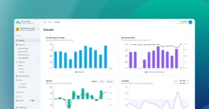
On the internal side, Power BI reports give planners and analysts a shared, real-time view of what is happening across the city’s streets. Teams that previously operated from different spreadsheets now work from the same data. Requests that used to take days to fulfil are answered instantly because the data is already there, already processed, already visible.
The decision that changed the trajectory of the project was launching before everything was ready. The team released what was already working and kept building from there, guided by real use rather than theoretical completeness. “That decision to prioritise real value over perfection turned a stalled initiative into a living, evolving service,” says Tafvelin. It also created something rarer in the public sector, IT momentum.

"That decision to prioritise real value over perfection turned a stalled initiative into a living, evolving service."
Johan Iversen, Data Engineer and Systems Architect at Devies
How Stadsbyggnadsförvaltningen continues to build on solid ground
The Traffic Catalogue is not a finished product. It is a platform. And that distinction matters for what the city can now do with it.
Planners and analysts can initiate new infrastructure projects with actual evidence behind them. Departments that once disagreed about traffic numbers now start from the same place. When a new source of data comes online, there is a model to absorb it into. Quality issues surface automatically rather than hiding inside spreadsheets until someone finds them the hard way.
The work began with fixing the foundation. What it enabled is a city that can make smarter decisions about how its streets work, backed by data that reflects the real movement of real people. When you walk through Gothenburg today and look at the traffic on a street, the numbers in the catalogue represent that. Not an estimate. Not a projection. The actual city.
That is what trustworthy data makes possible.